Mapa Geografico Ecuador Actualizado Shows New Changes

Mapa geographic Ecuador updated: what's different now
The updated Ecuador map now reflects the country's official cartography more accurately, especially in the Galápagos, maritime zones, and the relationship between the insular and continental territories. Ecuador's military geography institute presented the new official maps on December 17, 2024, after more than four years of technical work and a 12-year gap since the previous edition.
What changed
The most important change in the official cartography is that Galápagos is no longer treated as a detached visual box; it is shown in a way that better represents its real position relative to the mainland. The new edition also incorporates Ecuador's maritime spaces and highlights boundaries with Colombia, Peru, and Costa Rica more clearly than older maps.
The new geographic map was published at a scale of 1:500,000, while the physical map was issued at 1:1,000,000, and a special physical map covering continental, insular, and maritime territory was also introduced at 1:2,400,000. Those scale choices matter because they determine how much detail a user can see about relief, settlements, roads, and coastline structure.
Why it matters
For students, journalists, logistics teams, and travelers, the updated territorial reference is useful because it provides a more faithful picture of Ecuador's geography and jurisdiction. It also reduces confusion in classrooms and in public-facing materials that still rely on outdated map layouts.
From a practical standpoint, the newer maps are more aligned with modern GIS methods and digital terrain modeling, which improves how elevations, rivers, populated areas, and transport corridors are represented. That makes the map better suited to planning, education, and general geographic reference.
Core geographic facts
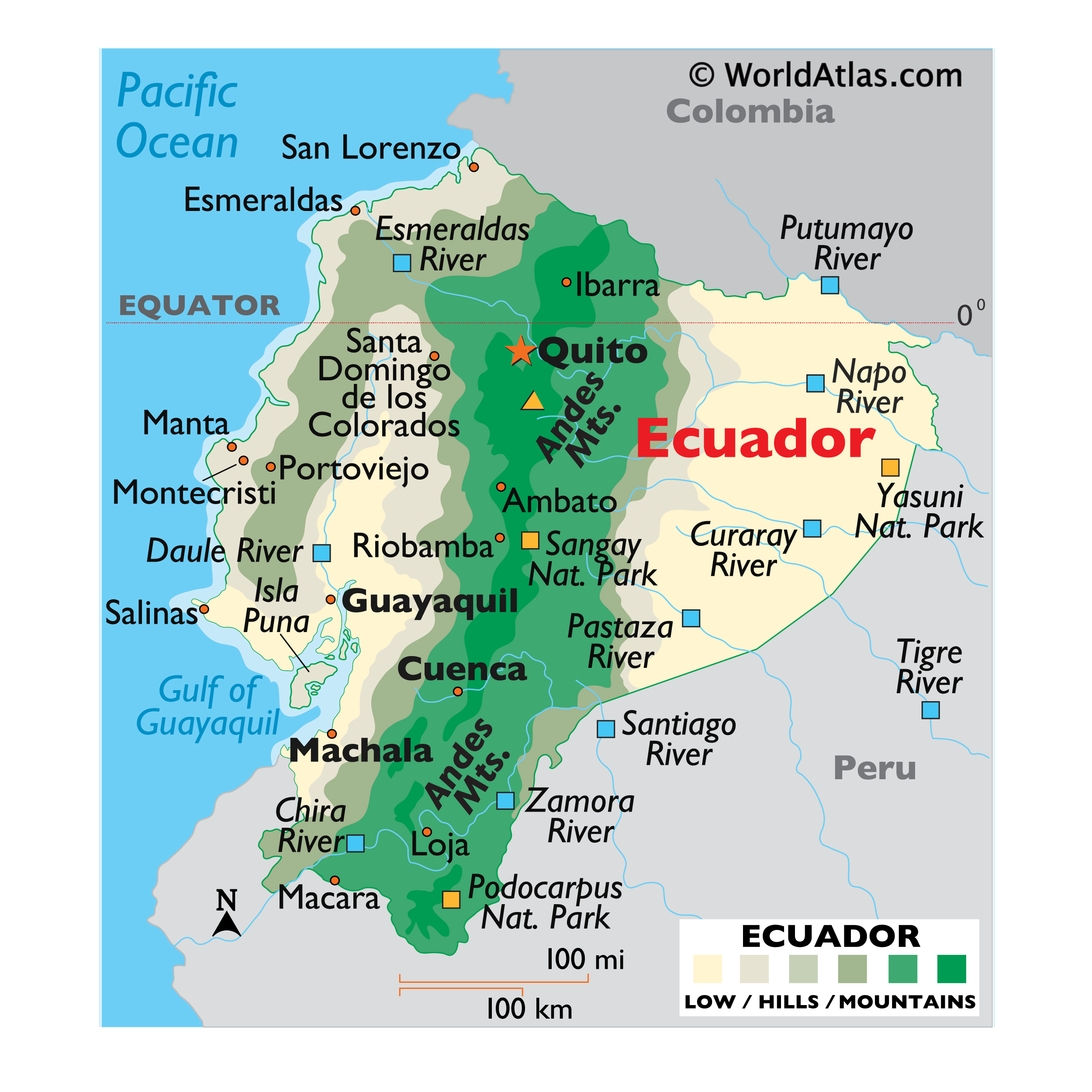
Ecuador remains a compact but highly diverse country in northwestern South America, with coastal lowlands, the Andes, Amazonian foothills, and the Galápagos Islands. Standard reference sources place the country's total area at about 283,561 square kilometers, including the islands, which helps explain why updated national mapping is so important.
| Item | Updated reference | Why it helps |
|---|---|---|
| Official geographic map scale | 1:500,000 | Better national-level reading of regions and major features |
| Official physical map scale | 1:1,000,000 | Useful for relief and terrain overview |
| Special territorial map | 1:2,400,000 | Shows continental, insular, and maritime territory together |
| Key visual update | Galápagos integrated with mainland context | Improves understanding of Ecuador's full geography |
Important regions
The updated regional layout still centers on Ecuador's four broad geographic zones: the Coast, the Andes, the Amazon, and the Galápagos. Each zone has distinct landforms, settlement patterns, and environmental conditions, so a current map is valuable for understanding how the country actually functions spatially.
- Coast: Lowlands, ports, agriculture, and major urban corridors.
- Andes: High elevations, volcanic relief, and the political core around Quito.
- Amazon: Forested eastern territory with lower mountains and river systems.
- Galápagos: Insular territory far west of the mainland, now shown more realistically.
How to read it
When reading an updated political map, start with provinces, then move down to cantons and major cities, and finally compare them with physical features such as mountain chains, rivers, and coastlines. Ecuador is still organized as a republic with 24 provinces, and that administrative structure remains the most important political layer for most users.
- Identify the province boundaries first.
- Locate Quito, Guayaquil, Cuenca, and other major cities.
- Compare the coastline, Andes ridge, and Amazon basin.
- Check the Galápagos placement relative to the mainland.
- Use the map scale to judge how much detail is visible.
Historical context
The release of the new official map is significant because it came after a long period without a full national update, and the government framed it as a modernization effort. According to the official presentation, the work involved technical and interinstitutional coordination, which is typical for national cartography projects that must reconcile geography, boundaries, and public-use standards.
"The Insular Region is no longer an isolated box. The maps now show our entire territory, including maritime limits with Colombia, Peru, and Costa Rica."
Practical uses
The updated national map is especially helpful for education, public administration, transport planning, tourism, and basic geographic literacy. It is also a better reference when a user wants a printable Ecuador map that reflects the country as it is officially represented today.
For online search users, the phrase "mapa geografico ecuador actualizado" usually means they want a current map showing provinces, major relief, and the Galápagos in a more accurate position. If the goal is classroom use, a political map is often best; if the goal is terrain analysis, the physical version is the better choice.
What to look for
A trustworthy updated map of Ecuador should clearly label the 24 provinces, show Quito and other major cities, represent the Andes correctly, and include the Galápagos with its maritime context. It should also avoid outdated inset-box designs that separate the islands too aggressively from the mainland.
- 24 provinces clearly marked.
- Galápagos integrated with appropriate geographic context.
- Readable rivers, mountain ranges, and coastlines.
- Maritime territory shown when relevant.
- Scale and legend visible for interpretation.
Frequently asked
Bottom line for users
The latest Ecuador map is more accurate, more complete, and better aligned with modern geographic standards than older versions. For anyone searching "mapa geografico Ecuador actualizado," the best answer is a current official map that shows the country's provinces, terrain, Galápagos, and maritime dimension in one coherent national frame.
Helpful tips and tricks for Mapa Geografico Ecuador Actualizado Shows New Changes
Is Ecuador's official map really updated?
Yes, the official cartography was updated and publicly presented on December 17, 2024, after more than 12 years without a new edition.
Does the new map change Ecuador's borders?
No, the update improves representation and precision, but it does not change Ecuador's internationally recognized territory.
Why is Galápagos shown differently?
Because the new design better reflects the islands' real geographic relationship to the continental territory and includes maritime space in the national view.
What map scale should I use for school?
Use the 1:500,000 geographic map for general schooling and the 1:1,000,000 physical map if you want a simplified terrain overview.